Monday, February 21, 2011

Final Days


Auckland Harbour
My last few days were spent in Auckland visiting with my cousin. The first day was drizzly and overcast so not much to see there! My final day was hot and sunny again so we were shopping and stopped for lunch by the harbour. Had beautiful blue cod fish and chips with a snappy Pinot Gris from Trinity Hills. Delightful!


At the airport- all good things must come to an end.


Maori symbols


Koru: The beginning of life. It is taken from the shape of a new silver fern branch before it unfurls.
 Pekapeka: A mythical bat which foretells disaster.
 Hei Tiki : A talisman for the Maori . May be a fertillity symbol. The strength the persons character is displayed in the Tiki. Used to adorn the top of house entry way carvings. 
 Twist: Symbol of Friend ship and bonds between friends, families , lovers. Can be seen in single, double or triple twist forms.


                      Fish Hook- Hei Matua: Prosperity. Fish were plentiful for the Maori so they associated fish with prosperity.  


Manaia: Spiritual Guide. These typically have the head of a bird, body of a man, tail of a fish. Thus the person is protected over for sea, land and sky.


another curve in the road

New Zealand is made completely of volcanos- extinct and active. This means that it is the land of a million curves in the road, as you are just driving up and down these mountains. Rarely is their a sign for windy roads- unless it is a hari kari sort of situation . Looking on the map it would usually appear that the road was straight- this was cartographer deceit - they probably just couldn't fit in all those little curve marks on the paper without getting vertigo from the exercise.

Often I was ready to stop the journey and go back to my hotel because of the never ending bends !Just as one was about to despair though, a magnificent vista would appear causing you to be glad you suffered the road madness to get to the said destination.

The only thing worse than the continual bends are signs indicating the road is going to go through some sort of gorge. This meant several hundred hairpin bends, usually involving a cliff edge where the average speed to take the bend was 10 kms. On one particular gorge, it was wide enough for 1 and a half cars, but two cars and big trucks were actually using the road. No guard rails- these seem to not have reached NZ shores. The drop was a few hundred feet off the cliff, heavy mist was falling and I was routinely pushed right to edge by some antipidean version of a Mack truck. At one point I thought I should find a lay by to pull over but then determined I would likely not get back in the car again so thought I should stick it out. My cousin had told me it was such a pretty drive around there!! After reaching my destination, and carefully prising my fingers off the steering wheel, headed for the mini bar where a few gin and tonics restored my sense of well being and obliterated the memory of the trip well enough for me to continue on the next day.

My aunt in Christchurch had been telling me about a stretch of road near her holiday home. " trucks go over the cliff there every week" was her comment. "Why doesn't the transport agency put up guard rails " was my response. "Oh that might be an idea " was her surprised response.

Kiwi's


Food for thought - The people of New Zealand are probably the only nation to be have a nick name of their national animal. As Canadians we should be thankful that we do not share the nickname of our national animal.........  

I have had a bunch of people ask me what the sound of the Kiwi call is . Below is a link to a website that has both male and female calls. Males have a high pitched call. You can hear the female in the distance returning the call, but the female call is lower in tone. 

www.kamcom.co.nz/recognisingkiwi.htm

Check it out for some cool mating calls.

Buried Village of Te Wairo


15 kilometers outside of Rotorua is the buried village of Te Wairo. At this site were the Pink and White Terraces. These Silica terraces had been formed from the hot springs that poured down the mountain side, the minerals in the water creating different colours. The water cooled as it came down the terraces so various areas could be used for bathing , cooking and water source for the Maori villagers. The area became a huge attraction after the British settled New Zealand and the Maori became very wealthy acting as guides to the Terraces. 

Around June 7th, 1850, a group of tourists were in a boat on the lake with their Maori guide , Sophia. They saw a huku or war canoe approaching filled with warriors. As the boat came near the warriors  turned to dogs then disappeared. Sophia went to the village elder with the vision. The elder predicted a terrible event would happen because of the Maori's greed .Sure enough in the early morning of June 10, Mount Terawera erupted. While the volcanoe was some 7 kilometres from the village, the ash from the volcano buried the village and killed 120 people. 4 days after the eruptions the elder who had predicted the disaster was dug out of his whare seen above. 

The eruption created a 100 foot crater at Lake Rotomohana and covered the Terraces. The crater was eventually filled with water extending the lake size by about another third. While I was in NZ , researchers had discovered evidence that some of the terraces may still be intact at the bottom of the lake. They will be doing further excavation in the future.  

The banks at the sides of the whare indicate the height of the ash which covered the buildings. Experts believe that the A frame shape of the Maori whares saved many villagers as the ash could slide off the roof, but it was about 25 feet deep. Virtually all the European style buildings collapsed under the weight of the ash. This included a three storey hotel. One of the survivors of the eruptions was able to visit the area in 1930 when excavations commenced. he was able to give details of where buildings were located and who lived in area.


This avenue of Poplars survived the eruption. The missionary who had built up the village area in the mid 1850's had transported these poplars from Illinois. They had their tops cut off to make fence posts. My cousin , who is a horticulturist confirmed that it was common practice to top off the poplars as the tops would regenerate and keep the settlers supplied with wood for building.


Te Wairo Waterfall- 180 feet in total

Carvings from the Maori National Carving School - Rotorua


"I told you this was too big for a lawn ornament "


My back is killing me !


Were you surprised ? I was surprised.

One Bombay Sapphire too many!

No really- these carvings are totally amazing !

Rotorua

Pohutu and Prince of Wales Geyser: There are two geysers here. The small one to the left is the Prince of Wales geyser. It blows first, followed a few seconds later by Pohutu, the largest geyser in the southern hemisphere. They blow every few few minutes. The air temperature in this area is approximately 50 c. so you have tend to move away fairly quickly. There is a viewing area near by but the rocks around the area are fairly warm so not where you want to sit for a long time on a hot day!  

The springs flowing from the geysers are around 114 degrees. There river area below is cold water. Trout from the river are often caught in the boiling water flow thus cooking them on sight!

The rocks are coloured red and white due to the mineral content in the geyser water.

Boiling mud. They sell the mud for face packs and lotions. Apparently it is excellant for people with excemza. 

The town of Rotorua has hot springs all around so you can pitch up to private spas and have a soak in the thermal bath of your choosing. Great for arthritis sufferers.  

Monday, February 14, 2011

Lake Taupo- Waitomo Caves and Rotorua


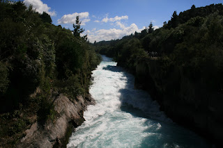
Huka Falls sits just above the town of Lake Taupo. While not the highest falls, it certainly is very powerful. Basically the river passes through a very narrow channel which creates the falls. Beautiful colour due to the mineral concentration from the volcanic soil in the area.


New Zealand is basically a huge range of volcanos and has many caves . Waitomo Caves are probably the best known as they have a huge colony of glow worms. The caves were discovered in the late 1880's and have been a top tourist spot ever since. This is the opening of the caves. Pictures were not allowed so sorry there are no glow worms to view- but it was very mystical inside. You travel through in a boat and they ask for total silence while in the caves. 


Lake Taupo is the largest and deepest lake in NZ. It is larger than Singapore! It is surrounded by a ring of extinct and active volcanoes and is in fact a crater that was formed by one of the largest eruptions in history. Ash from this volcano has been discovered in ice samplings as far away as Greenland! This is the start of the geothermal area of NZ, so lots of steam vents and boiling mud can be found near by.


This black swan seemed to follow me around the lake on my walks or sitting on the shore. Time to say good bye !

The Bath House at Rotorua.
Rotorua is the heart of the geothermal area of NZ . Over 500 springs from cold water to boiling hot. High sulpher concentration means the town suffers from the smell of rotten eggs! The above builiding was the original bath house but is now the town Museum. very beautiful inside in the grand English country house style. Visitors have been coming to this area since the mid 1800's to take the "cure" of the mineral spas. 
As I arrived here last night I just had time to go through the museum and then head to the spa house next door. Had a soak in the sulpher for about 20 minutes while looking out over Lake Rotorua. 
Today I am going to view the geysers and steam parks, view the buried maori village and do some shopping. I will be driving back up to Auckland this evening. 

Sunday, February 13, 2011

Lake Taupo

Whirinaki Falls on the road to Lake Taupo


Black Swans on Lake Taupo
 Boiling Mud at Craters of the Moon thermal area

Thermal pools at Craters of the Moon

The pink colors are silica layers formed from the mineral deposits from the thermal steam vents. 

Mount Ngauruhoe- Mount Doom in the Lord of the Rings trilogy.  

Napier Art Deco Gem


Napier is a sea side town on the east side of the North Island. Also famous for being one of the premier wine making districts of NZ - Hawkes Bay. 

In 1931 Napier suffered a devastating earthquake which destroyed the town. The rebuilding of the town resulted in an art deco jewel which has been maintained and promoted by subsequent town councils. The National Tobacco Company building is probably the best example of art deco style . The floral frieze is part of the main entrance. This is a wonderful town to spend a few hours strolling around. Sea side, gardens and wonderful builidings. 

The statue is of a Maori legend. Pania is a maori women who was drawn to the sirens of the sea. She was unable to return to the land because of her attraction to the gods of the sea,